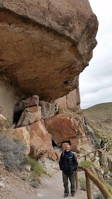
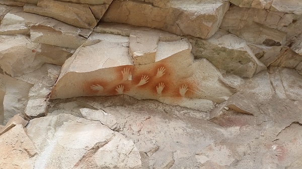
 La Grotta delle Mani e' un'area archeologica e centro turistico.
Qui si trovano dei disegni rupestri realizzati migliaia di anni fa dalle tribu semi-nomadi locali (precedenti ai tehuelches, gli indigeni della zona). Queste pitture rappresentano scene di caccia e impronte di mani, il cui significato non e' totalmente chiaro. Ci sono due teorie a riguardo: una che le identifica come simbolo di contatto e rispetto tra l'uomo e la terra, l'altra come parte di un rituale magico-curativo. Insomma non si sa.
Hanno iniziato a capirci qualcosa quando gli archeologi nel 1950 hanno iniziato a scavare il terreno trovando resti di utensili e animali, potendo cosi datare i disegni. In realta' le prime spedizioni sono avvenute nel 1881, ma gli scavi archeologici sono iniziati in maniera scientifica nel 1950. Solo nel 1999 la zona e' stata dichiarata Patrimonio Mondiale dell'UNESCO.
La Grotta delle Mani e' un'area archeologica e centro turistico.
Qui si trovano dei disegni rupestri realizzati migliaia di anni fa dalle tribu semi-nomadi locali (precedenti ai tehuelches, gli indigeni della zona). Queste pitture rappresentano scene di caccia e impronte di mani, il cui significato non e' totalmente chiaro. Ci sono due teorie a riguardo: una che le identifica come simbolo di contatto e rispetto tra l'uomo e la terra, l'altra come parte di un rituale magico-curativo. Insomma non si sa.
Hanno iniziato a capirci qualcosa quando gli archeologi nel 1950 hanno iniziato a scavare il terreno trovando resti di utensili e animali, potendo cosi datare i disegni. In realta' le prime spedizioni sono avvenute nel 1881, ma gli scavi archeologici sono iniziati in maniera scientifica nel 1950. Solo nel 1999 la zona e' stata dichiarata Patrimonio Mondiale dell'UNESCO.
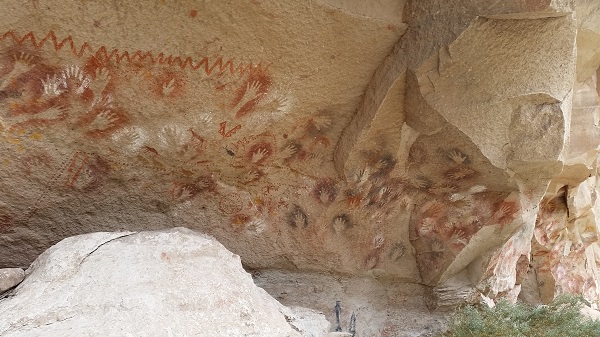 I disegni sono stati catalogati come appartenenti a diverse epoche: i piu antichi al 9.300AC, i piu recenti al 2.500AC. Come notava Pietro durante la visita, le pitture moderne sono piu complicate da interpretare in quanto astratte, un po come la nostra arte contemporanea. Interessante 🙂
Sulle pareti disegnate prevale il rosso, pigmento realizzato dalla combinazione di ossido di ferro e fluidi organici (come sangue, urina o saliva.. non si sa, dopo tutti questi anni la parte organica si e' dissolta), che gli indigeni mettevano in bocca e spruzzavano sulla mano realizzando un negativo della stessa. Chissa' che sapore!
Si contano piu di 800 impronte di mani di cui solamente 31 destre; questo rapporto paradossalmente identifica l'attuale percentuale di destri e mancini esistenti al mondo.
I disegni sono stati catalogati come appartenenti a diverse epoche: i piu antichi al 9.300AC, i piu recenti al 2.500AC. Come notava Pietro durante la visita, le pitture moderne sono piu complicate da interpretare in quanto astratte, un po come la nostra arte contemporanea. Interessante 🙂
Sulle pareti disegnate prevale il rosso, pigmento realizzato dalla combinazione di ossido di ferro e fluidi organici (come sangue, urina o saliva.. non si sa, dopo tutti questi anni la parte organica si e' dissolta), che gli indigeni mettevano in bocca e spruzzavano sulla mano realizzando un negativo della stessa. Chissa' che sapore!
Si contano piu di 800 impronte di mani di cui solamente 31 destre; questo rapporto paradossalmente identifica l'attuale percentuale di destri e mancini esistenti al mondo.
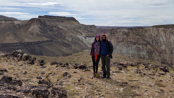
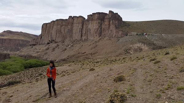
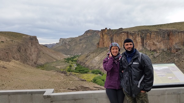
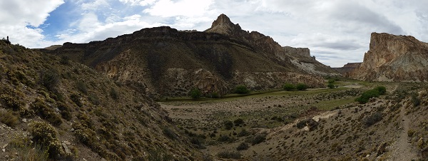
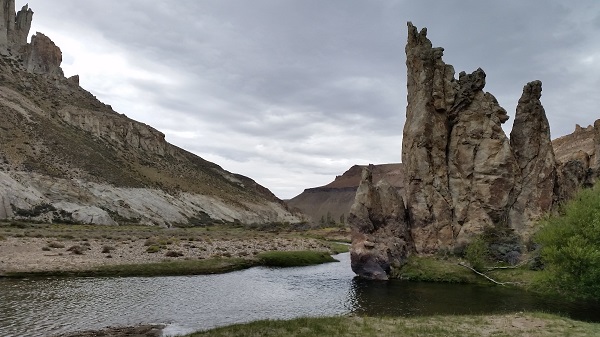 Il giro che abbiamo fatto e' durato una giornata: siamo andati con la jeep di Juan (detto Harry) fino alla fattoria los toldos, dove si puo iniziare un sentiero di 7 chilomentri che scende nel canyon Caracoles e costeggia il fiume Pinturas, prendendo il nome dalla grotta. Questo sentiero si snoda come un serpente tra la parte alta della montagna arida e ventosa, e la parte del fondo valle piu lussureggiante dove vivono liberamente condor, cavalli, mucche, guanacos, armadilli e puma. Ancora una volta siamo contenti di aver visto tutti questi animali tranne i gattoni.
Come arrivare:
Il giro che abbiamo fatto e' durato una giornata: siamo andati con la jeep di Juan (detto Harry) fino alla fattoria los toldos, dove si puo iniziare un sentiero di 7 chilomentri che scende nel canyon Caracoles e costeggia il fiume Pinturas, prendendo il nome dalla grotta. Questo sentiero si snoda come un serpente tra la parte alta della montagna arida e ventosa, e la parte del fondo valle piu lussureggiante dove vivono liberamente condor, cavalli, mucche, guanacos, armadilli e puma. Ancora una volta siamo contenti di aver visto tutti questi animali tranne i gattoni.
Come arrivare:
 da Perito Moreno ci sono solo due compagnie che vanno, quindi totale monopolio anche se fanno finta di farsi competizione. Offrono la stessa escursione allo stesso prezzo, magari sono anche parenti (eccole: Guanacondor e Zoyen).
Abbiamo cercato di prendere info prima di arrivare ma i siti ufficiali, comune e provincia, non sono accessibili: uno e' in costruzione e l'altro non esiste. Si nota la differenza tra il sud della Patagonia, come Ushuaia, El Calfate e El Chalten, che vivono unicamente di turismo, e il nord patagonico che vive prevalentemente di estrazione dal sottosuolo (miniere d'oro e petrolio).
Infatti, purtroppo, a Perito Moreno c'e' una proficua estrazione di oro e argento, realizzata con processi chimici che utilizzano cianuro e altre sostanze nocive che stanno inquinando l'ecosistema animale, umano e vegetale. La provincia ha permesso, con contratti di 30 anni a ben tre compagnie estrattive nord americane, di avere totale liberta' su questa zona. C'e' addirittura una miniera a ridosso di un'altra area archeologica, che e' stata chiusa al pubblico per motivi di sicurezza permettendo l'accesso solamente ai camion della compagnia. Logico no?
Siamo totalmente solidali con quei locali di Perito Moreno che combattono (senza speranza al momento) contro questi mostri. Per la cronaca, si sono alternate due amministrazioni politiche nazionali e provinciali di due schieramenti diversi e nessuno ha fatto niente. Neanche la tanto amata (da alcuni) e odiata (da altri) Cristina.
da Perito Moreno ci sono solo due compagnie che vanno, quindi totale monopolio anche se fanno finta di farsi competizione. Offrono la stessa escursione allo stesso prezzo, magari sono anche parenti (eccole: Guanacondor e Zoyen).
Abbiamo cercato di prendere info prima di arrivare ma i siti ufficiali, comune e provincia, non sono accessibili: uno e' in costruzione e l'altro non esiste. Si nota la differenza tra il sud della Patagonia, come Ushuaia, El Calfate e El Chalten, che vivono unicamente di turismo, e il nord patagonico che vive prevalentemente di estrazione dal sottosuolo (miniere d'oro e petrolio).
Infatti, purtroppo, a Perito Moreno c'e' una proficua estrazione di oro e argento, realizzata con processi chimici che utilizzano cianuro e altre sostanze nocive che stanno inquinando l'ecosistema animale, umano e vegetale. La provincia ha permesso, con contratti di 30 anni a ben tre compagnie estrattive nord americane, di avere totale liberta' su questa zona. C'e' addirittura una miniera a ridosso di un'altra area archeologica, che e' stata chiusa al pubblico per motivi di sicurezza permettendo l'accesso solamente ai camion della compagnia. Logico no?
Siamo totalmente solidali con quei locali di Perito Moreno che combattono (senza speranza al momento) contro questi mostri. Per la cronaca, si sono alternate due amministrazioni politiche nazionali e provinciali di due schieramenti diversi e nessuno ha fatto niente. Neanche la tanto amata (da alcuni) e odiata (da altri) Cristina.  Comunque abbiamo avuto una giornata fantastica e sicuramente ne e' valsa la pena.
The Cave of the Hands
 The Cave of the Hands is an archaeological site and touristic centre. Here there are rupest drawings made by the local semi-nomadic tribe (previous to the Tehuelches – natives of the area) thousands of years ago. These paintings represent hunting scenes and hand-prints, of which the meaning is not totally clear. There are two theories: one that identifies the paintings as symbol of contact and respect between man and Earth; while the other as part of un magical-healing ritual they used to do – for some reasons. So none knows.
 Archaeologists started to understand something when in the 1950 they started to dig the land finding
remains of tools and animals; in this way they were able to date the drawings. In reality the first expeditions took place in 1881, but archaeological excavations began, in a scientific way, in 1950. Only in 1999 the area was declared UNESCO World Heritage Site.
The drawings were categorized by different eras: the most ancient belonging to 9.300BC, the most recent to 2.500BC. As Pietro noted during the visit, the modern paintings are more complicated to interpret as they are abstract - somewhat like our contemporary art. That's interesting.
Archaeologists started to understand something when in the 1950 they started to dig the land finding
remains of tools and animals; in this way they were able to date the drawings. In reality the first expeditions took place in 1881, but archaeological excavations began, in a scientific way, in 1950. Only in 1999 the area was declared UNESCO World Heritage Site.
The drawings were categorized by different eras: the most ancient belonging to 9.300BC, the most recent to 2.500BC. As Pietro noted during the visit, the modern paintings are more complicated to interpret as they are abstract - somewhat like our contemporary art. That's interesting.
 On the painted walls prevails the red pigment produced by the combination of iron oxide and organic fluids (such as blood, urine or saliva... we do not know exactly as after all these years the organic part is dissolved). The indigenous used to put these fluids in the mouth and spray the mixture on the hand/s making a negative of them. What a great taste!
There are more than 800 hand-prints of which only 31 of right hand; paradoxically this relationship identifies the current percentage of right and left handed people in the world now-days.
On the painted walls prevails the red pigment produced by the combination of iron oxide and organic fluids (such as blood, urine or saliva... we do not know exactly as after all these years the organic part is dissolved). The indigenous used to put these fluids in the mouth and spray the mixture on the hand/s making a negative of them. What a great taste!
There are more than 800 hand-prints of which only 31 of right hand; paradoxically this relationship identifies the current percentage of right and left handed people in the world now-days.
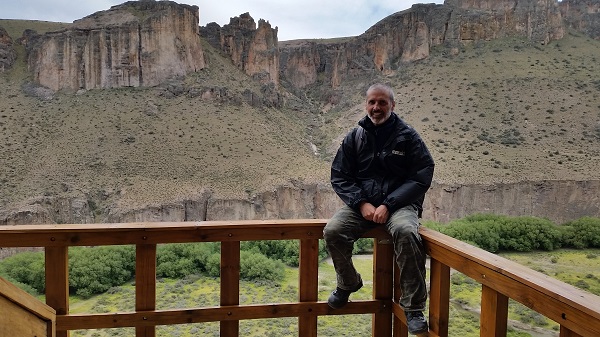 The tour we did lasted a day: we went with the 4WD jeep of Juan (called Harry) to the Los Toldos farm, where the path of 7 kilometers begins: we descended into the canyon Caracoles and walked along the river Pinturas, taking its name from the cave. This trail winds like a snake between the top of the arid and windy mountain and the green valley, where condors, horses, cows, guanacos, armadillos and pumas live freely. Once again we were happy to have seen all of these animals but the big cats.
Getting there:
The tour we did lasted a day: we went with the 4WD jeep of Juan (called Harry) to the Los Toldos farm, where the path of 7 kilometers begins: we descended into the canyon Caracoles and walked along the river Pinturas, taking its name from the cave. This trail winds like a snake between the top of the arid and windy mountain and the green valley, where condors, horses, cows, guanacos, armadillos and pumas live freely. Once again we were happy to have seen all of these animals but the big cats.
Getting there:
 from Perito Moreno, there are only two companies that go, so it is a total monopoly even if they pretend to be competitors: they offer the same trip at the same price - maybe they are even relatives (here they are: Guanacondor and Zoyen).
We tried to get info before arriving but the official sites, council and province, are not accessible: one is under construction and the other does not exist. We noticed the difference between the South of Patagonia, as Ushuaia, El Calfate and El Chalten, which live solely on tourism, and the Northern Patagonia living predominantly off extraction (precious metals mining and oil weels ).
from Perito Moreno, there are only two companies that go, so it is a total monopoly even if they pretend to be competitors: they offer the same trip at the same price - maybe they are even relatives (here they are: Guanacondor and Zoyen).
We tried to get info before arriving but the official sites, council and province, are not accessible: one is under construction and the other does not exist. We noticed the difference between the South of Patagonia, as Ushuaia, El Calfate and El Chalten, which live solely on tourism, and the Northern Patagonia living predominantly off extraction (precious metals mining and oil weels ).
 In fact, Perito Moreno has a profitable extraction of gold and silver, unfortunately: this is done with chemical processes that use cyanide and other harmful substances, which are polluting the animal, human and vegetal ecosystem.
The province of San Cruz has allowed, with 30 years contracts, three North American companies to have total freedom on this area. There is even a mining site near another archaeological site, which has been closed to the public for safety reasons, allowing access only to trucks of the company. Logical right?
We have all our solidarity with those locals of Perito Moreno, who are fighting (hopeless at the moment) against these monsters. For the record, there have been two different National and Provincial administrations in charge belonging to different parties, but nobody has moved a finger. Not even the much-loved (by some) and hated (by others) Cristina.
Anyway we had a fantastic day and the Cueva de las Manos was worth it!
In fact, Perito Moreno has a profitable extraction of gold and silver, unfortunately: this is done with chemical processes that use cyanide and other harmful substances, which are polluting the animal, human and vegetal ecosystem.
The province of San Cruz has allowed, with 30 years contracts, three North American companies to have total freedom on this area. There is even a mining site near another archaeological site, which has been closed to the public for safety reasons, allowing access only to trucks of the company. Logical right?
We have all our solidarity with those locals of Perito Moreno, who are fighting (hopeless at the moment) against these monsters. For the record, there have been two different National and Provincial administrations in charge belonging to different parties, but nobody has moved a finger. Not even the much-loved (by some) and hated (by others) Cristina.
Anyway we had a fantastic day and the Cueva de las Manos was worth it!