 Siamo nell'estremo sud della Patagonia, dove finisce il mondo. Non e' vero, non finisce niente... se volassimo sopra l'Antartide, arriveremmo a casa.
Partiti da Puerto Madryn con un bus raggiungiamo Rio Gallegos dopo 18 ore, qui ci fermiamo per una doccia e una passeggiata. In questo posto tutti lavorano nell'estrazione di petrolio, in pratica non c'e' nulla di attraente per noi: solo freddo e bus che vanno e vengono.
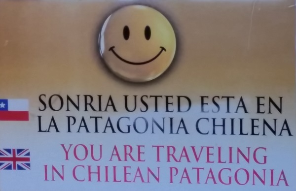
Il giorno dopo prendiamo un altro autobus per Ushuaia che impiega 12 ore per arrivare, passando entrambi le dogane argentina e cilena per ben due volte e imbarcandosi sul traghetto per attraversare lo Stretto di Magellano. Il fatto di saltare tra la Patagonia argentina e cilena e' buffo, per esempio nella prima dogana abbiamo trovato un container dove c'era l'ufficio immigrazione con gli impiegati di entrambe i paesi: si entra dalla parte argentina e si esce in quella cilena, gli addetti condividono la scrivania, creando un'efficente catena di montaggio.
Siamo nell'estremo sud della Patagonia, dove finisce il mondo. Non e' vero, non finisce niente... se volassimo sopra l'Antartide, arriveremmo a casa.
Partiti da Puerto Madryn con un bus raggiungiamo Rio Gallegos dopo 18 ore, qui ci fermiamo per una doccia e una passeggiata. In questo posto tutti lavorano nell'estrazione di petrolio, in pratica non c'e' nulla di attraente per noi: solo freddo e bus che vanno e vengono.
Il giorno dopo prendiamo un altro autobus per Ushuaia che impiega 12 ore per arrivare, passando entrambi le dogane argentina e cilena per ben due volte e imbarcandosi sul traghetto per attraversare lo Stretto di Magellano. Il fatto di saltare tra la Patagonia argentina e cilena e' buffo, per esempio nella prima dogana abbiamo trovato un container dove c'era l'ufficio immigrazione con gli impiegati di entrambe i paesi: si entra dalla parte argentina e si esce in quella cilena, gli addetti condividono la scrivania, creando un'efficente catena di montaggio.
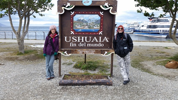
 Arriviamo ad Ushuaia e ci accolgono 5 gradi e neve tutto intorno. Eravamo equipaggiati, ma mentalmente io ero ancora tra i leoni marini con il costumino.
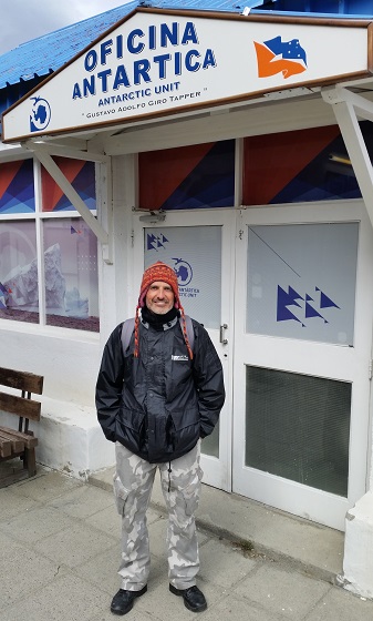
Il primo giorno lo passiamo a prendere informazioni per capire come risalire la Patagonia ed incastrare tutto quello che vogliamo vedere. Eccitante per me, stressante per Pietro. Purtroppo realizziamo che dobbiamo tagliare Bariloche dai piani iniziali, se vogliamo tornare a Baires per Natale. Ci vorrebbero 4/5 giorni solo per fare un giro in questa zona di laghi. Putroppo non li abbiamo.
Arriviamo ad Ushuaia e ci accolgono 5 gradi e neve tutto intorno. Eravamo equipaggiati, ma mentalmente io ero ancora tra i leoni marini con il costumino.
Il primo giorno lo passiamo a prendere informazioni per capire come risalire la Patagonia ed incastrare tutto quello che vogliamo vedere. Eccitante per me, stressante per Pietro. Purtroppo realizziamo che dobbiamo tagliare Bariloche dai piani iniziali, se vogliamo tornare a Baires per Natale. Ci vorrebbero 4/5 giorni solo per fare un giro in questa zona di laghi. Putroppo non li abbiamo.
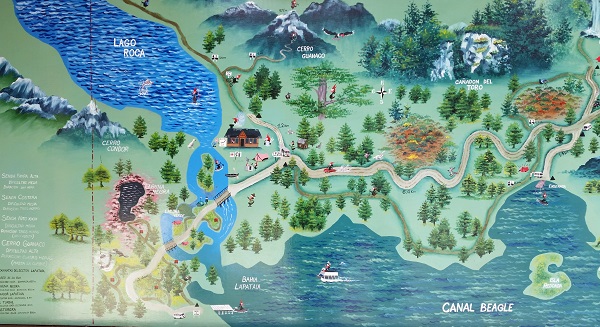
 Il secondo giorno andiamo al parco della Terra del Fuoco, che conta 68 mila ettari della parte estrema australe della Cordigliera delle Ande, estendendosi tra Lago Fagnano e Canale Beagle. Per andare al parco ci sono diverse opzioni: camminare, prendere un taxi con altre persone abbattendo notevolmente i costi o prendere una navetta per 200 pesos che ti porta e ti viene a riprendere, accordando la fermata nel parco. L'entrata del parco e' a parte e sono 215 pesos per noi gringos, mentre 30 pesos per gli argentini.
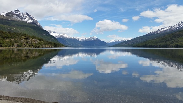
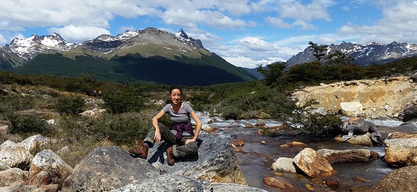
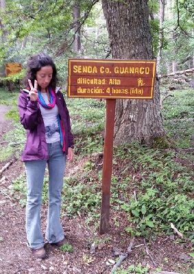 Qui ci sono diversi sentieri; noi scegliamo il sentiero Guanaco che consiste in 4 chilometri in salita per raggiungere la vetta. Dobbiamo ammettere che siamo due masochisti. Il sentiero e' il piu difficile e impegnativo, ma anche il piu suggestivo in quanto permette la vista del parco dall'alto compresi lago Roca, diviso tra Cile e Argentina, Cordigliera e canale. Ci siamo fermati dopo due chilometri di strada in salita nel bosco tra fango ed enormi radici, in una specie di belvedere naturale. Camminare in questa pseudo-pianura e' strano, il manto della montagna e' ricoperto da una moquette di erba cespugliosa fitta fitta e bagnaticcia, per via dello scioglimento della neve.
Questa giornata e' stata stancante, ma molto soddisfacente: penso sia stata la merenda piu scenica che abbiamo fatto fino ad oggi 🙂
(Coordinate geografiche 54.8180 sud e 65.5535 ovest, a 800 metri sul mare – Info gentilmente fornite da Pman!)
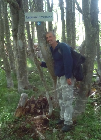
Il giono dopo andiamo a Laguna Esmeralda, che si rivela una vera passeggiata dopo il massacro del giorno prima. Siamo in compagnia di tre ragazzi brasiliani, che non smettono un attimo di parlare, anche in italiano. Infatti tra loro c'e' Ronian, insegnate di inglese che parla italiano, alloggia nel nostro stesso ostello e si e' rivelato un piacevolissimo compagno di viaggio.
Qui ci sono diversi sentieri; noi scegliamo il sentiero Guanaco che consiste in 4 chilometri in salita per raggiungere la vetta. Dobbiamo ammettere che siamo due masochisti. Il sentiero e' il piu difficile e impegnativo, ma anche il piu suggestivo in quanto permette la vista del parco dall'alto compresi lago Roca, diviso tra Cile e Argentina, Cordigliera e canale. Ci siamo fermati dopo due chilometri di strada in salita nel bosco tra fango ed enormi radici, in una specie di belvedere naturale. Camminare in questa pseudo-pianura e' strano, il manto della montagna e' ricoperto da una moquette di erba cespugliosa fitta fitta e bagnaticcia, per via dello scioglimento della neve.
Questa giornata e' stata stancante, ma molto soddisfacente: penso sia stata la merenda piu scenica che abbiamo fatto fino ad oggi 🙂
(Coordinate geografiche 54.8180 sud e 65.5535 ovest, a 800 metri sul mare – Info gentilmente fornite da Pman!)
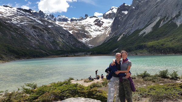
Il giono dopo andiamo a Laguna Esmeralda, che si rivela una vera passeggiata dopo il massacro del giorno prima. Siamo in compagnia di tre ragazzi brasiliani, che non smettono un attimo di parlare, anche in italiano. Infatti tra loro c'e' Ronian, insegnate di inglese che parla italiano, alloggia nel nostro stesso ostello e si e' rivelato un piacevolissimo compagno di viaggio.
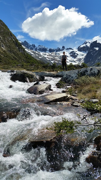
 L'escursione dura 5 ore, due per salire e un po meno per scendere e il resto passato seduti in riva alla laguna a prendere il sole e godendo del paesaggio che si presenta con dei colori incredibili. L'acqua della laguna formata dal ghiacciaio ha un colore turchese, inconfondibile e meraviglioso (questo e' dato dall'asssenza di polvere nel ghiaccio purissimo che si scioglie - e' il massimo della spiegazione scientifica che posso dare).
 Per andare all'entrata del sentiero abbiamo contrattato il passaggio con Miguelito, che ci viene a prendere puntualissimo alle 4 di pomeriggio, portandoci a sorpresa la merenda: delle pastarelle giganti buonissime e succo di frutta. Miguel e' di Missiones, la regione dove si trovano le cascate di Iguazu e dove le persone sono rinomate per la gentilezza e la generosita'. Confermiamo, anche quando giocano fuori casa mantengono queste caratteristiche.
Altra cosa da non perdere e' la crociera nel canale Beagle, quando c'e' il sole ci sono dei colori incredibili sia dell'acqua che della costa rocciosa intorno; si fa un giro rilassante fino al faro e si torna, sicuramente si apprezza di piu con una barca di piccole-medie dimensioni e con pochi turisti intorno.
Per andare all'entrata del sentiero abbiamo contrattato il passaggio con Miguelito, che ci viene a prendere puntualissimo alle 4 di pomeriggio, portandoci a sorpresa la merenda: delle pastarelle giganti buonissime e succo di frutta. Miguel e' di Missiones, la regione dove si trovano le cascate di Iguazu e dove le persone sono rinomate per la gentilezza e la generosita'. Confermiamo, anche quando giocano fuori casa mantengono queste caratteristiche.
Altra cosa da non perdere e' la crociera nel canale Beagle, quando c'e' il sole ci sono dei colori incredibili sia dell'acqua che della costa rocciosa intorno; si fa un giro rilassante fino al faro e si torna, sicuramente si apprezza di piu con una barca di piccole-medie dimensioni e con pochi turisti intorno.
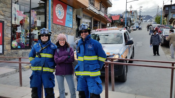 Ushuaia paese e' una Saint Moritz patagonica: nasce come colonia penale (siamo a casa!), diventa nel 1950 base nautica militare, cresce con la ricerca dell'oro e il mercato del legno e della pesca, per essere oggi uno tra i centri turistici piu famosi al mondo. Ci sono lavori ovunque di construzione, rinnovo, abbellimento e restauro, siamo sicuri che questo posto non si riconoscera' piu tra qualche anno. Abbiamo socializzato con la protezione civile del posto :).
Ushuaia – the end of the world
 We are at the extreme South of the Patagonia, where the world ends. Not true, if we fly over Antartide, we would arrive at home.
After having left Puerto Madryn by bus, we arrived at Rio Gallegos after 18 hours; here we stopped for a shower and a walk. In this place everyone works in the extraction of petrol, basically there is nothing for us: only cold and buses that come and go.
The day after we caught another bus to Ushuaia, which took 12 hours to arrive, passing twice through both customs – Argentinean and Chilean, and boarding on the ferry to cross the Magellan Strait. The fact of jumping between the Argentinean Patagonia and the Chilean one is quite funny; for example in the first custom we found a container where there is the immigration office with both countries' employees: you walk-in from the Argentinean side and walk-out to the Chilean part, even the officers share the desk, creating an efficient production line.
We are at the extreme South of the Patagonia, where the world ends. Not true, if we fly over Antartide, we would arrive at home.
After having left Puerto Madryn by bus, we arrived at Rio Gallegos after 18 hours; here we stopped for a shower and a walk. In this place everyone works in the extraction of petrol, basically there is nothing for us: only cold and buses that come and go.
The day after we caught another bus to Ushuaia, which took 12 hours to arrive, passing twice through both customs – Argentinean and Chilean, and boarding on the ferry to cross the Magellan Strait. The fact of jumping between the Argentinean Patagonia and the Chilean one is quite funny; for example in the first custom we found a container where there is the immigration office with both countries' employees: you walk-in from the Argentinean side and walk-out to the Chilean part, even the officers share the desk, creating an efficient production line.
 When we arrived to Ushuaia, there were 5 degrees and snow all around. We were well equipped, but mentally I was still between the sea lions with my bikini.
The first day was for 'buscar les informaciones' (looking for info) on how to go back up from Patagonia and to 'play tetris' with all places we want to visit. Exciting exercise for me, stressful for Pietro. Unfortunately we needed to give up on Bariloche, if we wanted to reach Baires for Christmas. It would have needed 4/5 day to explore this area with the lakes, and we didn't have this time.
When we arrived to Ushuaia, there were 5 degrees and snow all around. We were well equipped, but mentally I was still between the sea lions with my bikini.
The first day was for 'buscar les informaciones' (looking for info) on how to go back up from Patagonia and to 'play tetris' with all places we want to visit. Exciting exercise for me, stressful for Pietro. Unfortunately we needed to give up on Bariloche, if we wanted to reach Baires for Christmas. It would have needed 4/5 day to explore this area with the lakes, and we didn't have this time.
 The second day we went to Tierra del Fuego National Park, which counts 68 thousands hectare of the extreme part of the austral Cordillera of the Andes, covering the land between Fagnano Lake and Beagle Cannel. To go to the park there are few options: walking, taking a taxi with other people to share the fare or catching a shuttle bus for 200 pesos. This last option would take you to destination and pick you up at a bus stop inside the park. The entry to the park is not included and it is 215 pesos for the gringos and 30 pesos for the locals.
 Here there are several paths; we picked the Guanaco Sendero which consisted in 4 km up hill to reach the top of the mountain. We need to admit we are two masochists! This is the most difficult and challenging path, but also the most suggestive one as it allows to overlook the park from the top, including Roca Lake (shared between Chile and Argentina), the Cordigliera and the Cannel. We stopped in a sort of natural lookout after climbing 2 steep km in the bush between mud and enormous roots. Walking on this semi-platou is strange, the mantle of the mountain is covered by this dense, wet and bushy grass (like carpet), as the snow is melting.
This day was a total killer, but really satisfactory: I think this was the most scenic avo snack we have done so far 🙂
Here there are several paths; we picked the Guanaco Sendero which consisted in 4 km up hill to reach the top of the mountain. We need to admit we are two masochists! This is the most difficult and challenging path, but also the most suggestive one as it allows to overlook the park from the top, including Roca Lake (shared between Chile and Argentina), the Cordigliera and the Cannel. We stopped in a sort of natural lookout after climbing 2 steep km in the bush between mud and enormous roots. Walking on this semi-platou is strange, the mantle of the mountain is covered by this dense, wet and bushy grass (like carpet), as the snow is melting.
This day was a total killer, but really satisfactory: I think this was the most scenic avo snack we have done so far 🙂 (Geographical coordinates 54.8180 South and 65.5535 West, at 800 metres on the sea level – info kindly provided by Pman!)
 The day after we went to the Esmerald Laguna, which was a piece of cake comparing the massacre of the day before. We were in company of three Brasilian guys, who did not stop talking for a second, even in Italian. In fact amongst them, there is Ronian, English teacher who speaks Italian, he stays at our hostel; he reveals to be a great traveling buddy.
The excursion lasted 5 hours, two to go up and a bit less to come down; the rest spent sitting along the laguna sun-bathing and enjoying the landscape, which presented incredible colours.
The water of the laguna comes from the glaciar and it has a turquoise colour, really distintive and wonderful (this happens because of the absence of the dust in the pure ice, that melts from the glaciar – this is the best of scientific explanation I can provide).
To arrive at the entrance of the path, we negotiated a lift with Miguelito, who came to pick us up precisely at 4pm, bringing a snack: gigantic and delicious pastries and orange juice. Miguel is from Missions, the region where there are the Iguazu waterfalls and where people is well-known to be kind and generous. We confirm, they keep these characteristics even when they are away from their hometown.
The day after we went to the Esmerald Laguna, which was a piece of cake comparing the massacre of the day before. We were in company of three Brasilian guys, who did not stop talking for a second, even in Italian. In fact amongst them, there is Ronian, English teacher who speaks Italian, he stays at our hostel; he reveals to be a great traveling buddy.
The excursion lasted 5 hours, two to go up and a bit less to come down; the rest spent sitting along the laguna sun-bathing and enjoying the landscape, which presented incredible colours.
The water of the laguna comes from the glaciar and it has a turquoise colour, really distintive and wonderful (this happens because of the absence of the dust in the pure ice, that melts from the glaciar – this is the best of scientific explanation I can provide).
To arrive at the entrance of the path, we negotiated a lift with Miguelito, who came to pick us up precisely at 4pm, bringing a snack: gigantic and delicious pastries and orange juice. Miguel is from Missions, the region where there are the Iguazu waterfalls and where people is well-known to be kind and generous. We confirm, they keep these characteristics even when they are away from their hometown.
 Another thing not to be missed is the Beagle Cannel cruise; when it is sunny there are incledible colours in the water and all around the costal rocks. The cruise arrived down to the lighthouse and back, in a relaxing atmosfeare; this can be really appreciated in a medium-small size boat with just few turists around.
Ushuaia village is like a Patagonic Saint Moritz: it was born as penal colony (we felt at home!), it became a military nautical base in 1950, grew with the gold mining, the wood and fishing market, to be nowadays one of the most touristic centers in the world. There are roads and house' works everywhere to build, renew, embelish and restore.. we are pretty sure that it will be really hard to reconise this place in few year.
Another thing not to be missed is the Beagle Cannel cruise; when it is sunny there are incledible colours in the water and all around the costal rocks. The cruise arrived down to the lighthouse and back, in a relaxing atmosfeare; this can be really appreciated in a medium-small size boat with just few turists around.
Ushuaia village is like a Patagonic Saint Moritz: it was born as penal colony (we felt at home!), it became a military nautical base in 1950, grew with the gold mining, the wood and fishing market, to be nowadays one of the most touristic centers in the world. There are roads and house' works everywhere to build, renew, embelish and restore.. we are pretty sure that it will be really hard to reconise this place in few year.